EditorialCreativeSportKollektionenVideos
Preise
0Anmelden

Visuelle Inhalte für Profis.
800 Mio.+ Bilder und Videos.

Content-Hub

  • Aktuelle Ereignisse
  • Bilder des Jahres
  • Sport
  • Editorial
  • Creative
  • Kollektionen
  • Videos

Angebote

  • Preise & Pakete
  • Aktionen
  • Enterprise
  • Newsletter
  • Blog
  • The Game Magazine

Services

  • Bildrecherche
  • Auftragsfotografie
  • API & FTP Push
  • my-picturemaxx
  • Partner werden

Unternehmen

  • Über IMAGO
  • Karriere
  • News

Hilfe-Center

  • FAQ
  • Kontakt
ImpressumNutzungsbedingungenLizenzinformationenDatenschutzDatenschutzeinstellungen
© 2026 IMAGO
CEPICBAPLABVPA
Zurück zu den Kollektionen

NRW, Rhein führt Niedrigwasser

20.07.2026

Die folgenden Fotos wurden von der IMAGO Bildredaktion zu diesem Thema für Sie ausgewählt. Für weitere Bilder nutzen Sie bitte die Suchfunktion.
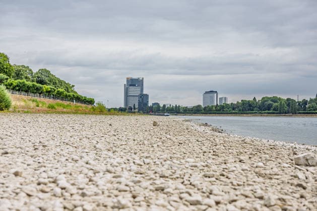
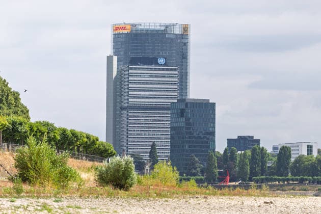
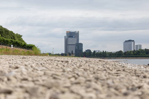
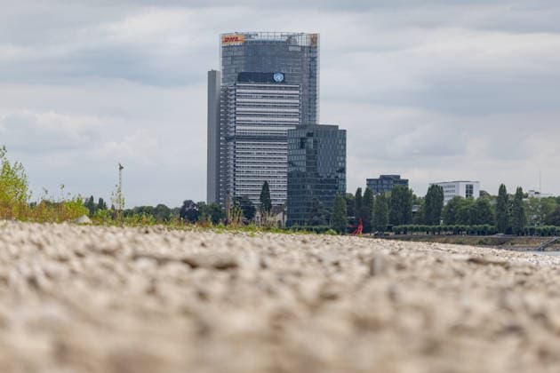
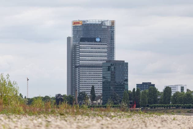
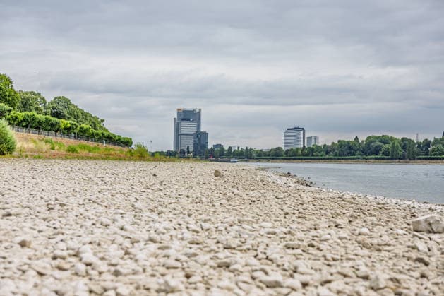
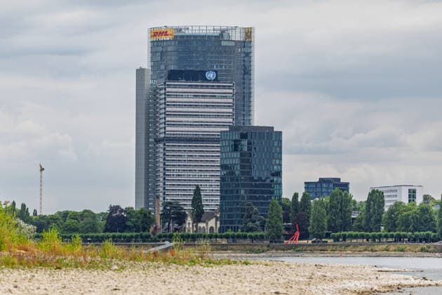
  • Niedrigwasser am Rhein vor dem UN Campus in Bonn Niedrigwasser am Rhein: Bei einem Pegelstand von 125 cm am Pegel Bonn liegt das Flussbett bis auf die tiefer liegende Fahrrinne trocken. Im Hintergrund das Hochhaus-Ensemble aus Post Tower, Langer Eugen und Climate Tower auf dem UN Campus, wo das Sekretariat der UN-Klimarahmenkonvention UNFCCC über den globalen Klimaschutz verhandelt. Bonn Beuel Nordrhein-Westfalen Deutschland *** Low Water Levels on the Rhine in Front of the UN Campus in Bonn Low Water Levels on the Rhine With the water level at 125 cm at the Bonn gauge, the riverbed is dry except for the lower-lying navigation channel. In the background is the high-rise complex consisting of the Post Tower, Langer Eugen, and Climate Tower Copyright: xMarcxJohnx
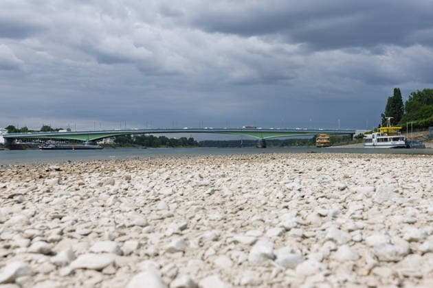
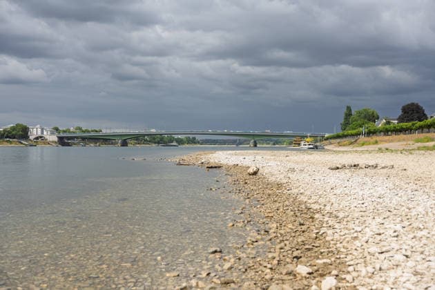
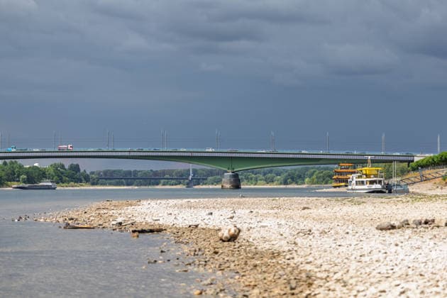
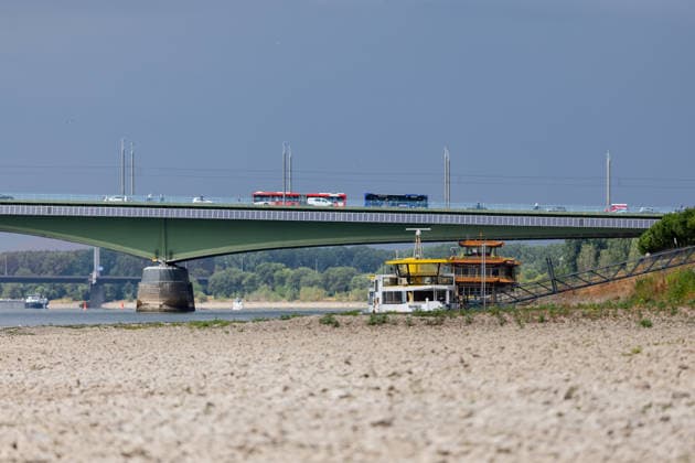
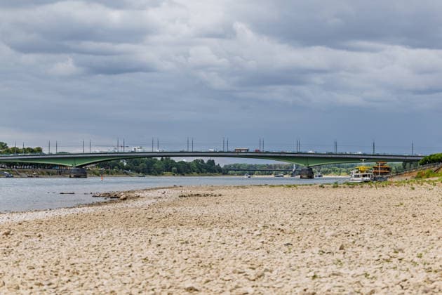
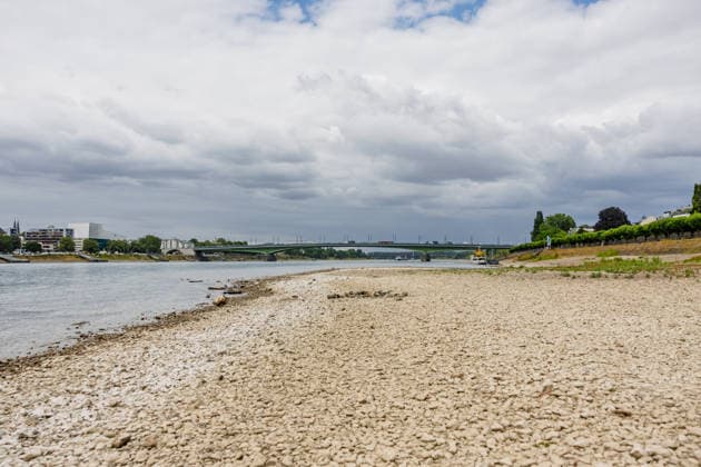
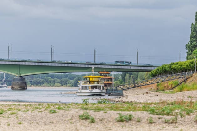
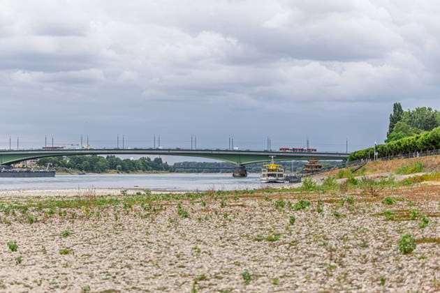
  • Niedrigwasser am Rhein in Bonn-Beuel Niedrigwasser am Rhein: Bei einem Pegelstand von 125 cm am Pegel Bonn liegt das Flussbett am Beueler Rheinufer bis auf die tiefer liegende Fahrrinne trocken. Blick nach Norden auf die stark befahrene Kennedybrücke, im Hintergrund die gesperrte Nordbrücke (Friedrich-Ebert-Brücke). Bonn Beuel Nordrhein-Westfalen Deutschland *** Low Water Levels on the Rhine in Bonn-Beuel Low Water Levels on the Rhine With the water level at the Bonn gauge station at 125 cm, the riverbed along the Beuel bank of the Rhine is dry except for the lower-lying navigation channel; view looking north toward the heavily trafficked Kennedy Bridge, with the closed Nordbrücke in the background. Friedrich Ebert Bridge, Bonn-Beuel, No Copyright: xMarcxJohnx
  • Niedrigwasser am Rhein vor dem UN Campus in Bonn Niedrigwasser am Rhein: Bei einem Pegelstand von 125 cm am Pegel Bonn liegt das Flussbett bis auf die tiefer liegende Fahrrinne trocken. Im Hintergrund das Hochhaus-Ensemble aus Post Tower, Langer Eugen und Climate Tower auf dem UN Campus, wo das Sekretariat der UN-Klimarahmenkonvention UNFCCC über den globalen Klimaschutz verhandelt. Bonn Beuel Nordrhein-Westfalen Deutschland *** Low Water Levels on the Rhine in Front of the UN Campus in Bonn Low Water Levels on the Rhine With the water level at 125 cm at the Bonn gauge, the riverbed is dry except for the lower-lying navigation channel. In the background is the high-rise complex consisting of the Post Tower, Langer Eugen, and Climate Tower Copyright: xMarcxJohnx
  • Niedrigwasser am Rhein in Bonn-Beuel Niedrigwasser am Rhein: Bei einem Pegelstand von 125 cm am Pegel Bonn liegt das Flussbett am Beueler Rheinufer bis auf die tiefer liegende Fahrrinne trocken. Blick nach Norden auf die stark befahrene Kennedybrücke, im Hintergrund die gesperrte Nordbrücke (Friedrich-Ebert-Brücke). Bonn Beuel Nordrhein-Westfalen Deutschland *** Low Water Levels on the Rhine in Bonn-Beuel Low Water Levels on the Rhine With the water level at the Bonn gauge station at 125 cm, the riverbed on the Beuel side of the Rhine is dry except for the lower-lying navigation channel; view looking north toward the heavily trafficked Kennedy Bridge, with the closed Nordbrücke in the background. Friedrich Ebert Bridge, Bonn-Beuel, North Copyright: xMarcxJohnx
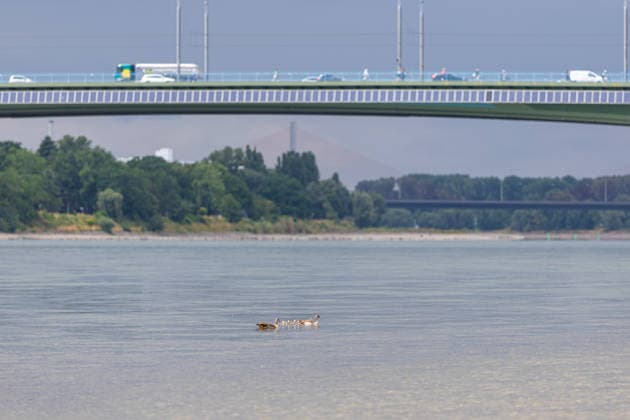
  • Niedrigwasser am Rhein in Bonn-Beuel Niedrigwasser am Rhein: Bei einem Pegelstand von 125 cm am Pegel Bonn liegt das Flussbett am Beueler Rheinufer bis auf die tiefer liegende Fahrrinne trocken. Blick nach Norden auf die stark befahrene Kennedybrücke, im Hintergrund die gesperrte Nordbrücke (Friedrich-Ebert-Brücke). Im Vordergrund eine Entenfamilie Bonn Beuel Nordrhein-Westfalen Deutschland *** Low Water Levels on the Rhine in Bonn Beuel Low Water Levels on the Rhine With the water level at the Bonn gauge station at 125 cm, the riverbed along the Beuel bank of the Rhine is dry except for the lower-lying navigation channel. View looking north toward the heavily trafficked Kennedy Bridge, with the closed Nordbrücke in the background; Fried Copyright: xMarcxJohnx
  • Niedrigwasser am Rhein in Bonn-Beuel Niedrigwasser am Rhein: Bei einem Pegelstand von 125 cm am Pegel Bonn liegt das Flussbett am Beueler Rheinufer bis auf die tiefer liegende Fahrrinne trocken. Blick nach Norden auf die stark befahrene Kennedybrücke, im Hintergrund die gesperrte Nordbrücke (Friedrich-Ebert-Brücke). Bonn Beuel Nordrhein-Westfalen Deutschland *** Low Water Levels on the Rhine in Bonn-Beuel Low Water Levels on the Rhine With the water level at the Bonn gauge station at 125 cm, the riverbed along the Beuel bank of the Rhine is dry except for the lower-lying navigation channel; view looking north toward the heavily trafficked Kennedy Bridge, with the closed Nordbrücke in the background. Friedrich Ebert Bridge, Bonn-Beuel, No Copyright: xMarcxJohnx
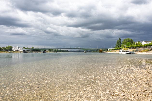
  • Niedrigwasser am Rhein in Bonn-Beuel Niedrigwasser am Rhein: Bei einem Pegelstand von 125 cm am Pegel Bonn liegt das Flussbett am Beueler Rheinufer bis auf die tiefer liegende Fahrrinne trocken. Blick nach Norden auf die stark befahrene Kennedybrücke, im Hintergrund die gesperrte Nordbrücke (Friedrich-Ebert-Brücke). Bonn Beuel Nordrhein-Westfalen Deutschland *** Low Water Levels on the Rhine in Bonn-Beuel Low Water Levels on the Rhine With the water level at the Bonn gauge station at 125 cm, the riverbed on the Beuel side of the Rhine is dry except for the lower-lying navigation channel; view looking north toward the heavily trafficked Kennedy Bridge, with the closed Nordbrücke in the background. Friedrich Ebert Bridge, Bonn-Beuel, North Copyright: xMarcxJohnx
  • Niedrigwasser am Rhein in Bonn-Beuel Niedrigwasser am Rhein: Bei einem Pegelstand von 125 cm am Pegel Bonn liegt das Flussbett am Beueler Rheinufer bis auf die tiefer liegende Fahrrinne trocken. Blick nach Norden auf die stark befahrene Kennedybrücke, im Hintergrund die gesperrte Nordbrücke (Friedrich-Ebert-Brücke). Bonn Beuel Nordrhein-Westfalen Deutschland *** Low Water Levels on the Rhine in Bonn-Beuel Low Water Levels on the Rhine With the water level at the Bonn gauge station at 125 cm, the riverbed on the Beuel side of the Rhine is dry except for the lower-lying navigation channel; view looking north toward the heavily trafficked Kennedy Bridge, with the closed Nordbrücke in the background. Friedrich Ebert Bridge, Bonn-Beuel, North Copyright: xMarcxJohnx
  • Niedrigwasser am Rhein in Bonn-Beuel Niedrigwasser am Rhein: Bei einem Pegelstand von 125 cm am Pegel Bonn liegt das Flussbett am Beueler Rheinufer bis auf die tiefer liegende Fahrrinne trocken. Blick nach Norden auf die stark befahrene Kennedybrücke, im Hintergrund die gesperrte Nordbrücke (Friedrich-Ebert-Brücke). Bonn Beuel Nordrhein-Westfalen Deutschland *** Low Water Levels on the Rhine in Bonn-Beuel Low Water Levels on the Rhine With the water level at the Bonn gauge station at 125 cm, the riverbed on the Beuel side of the Rhine is dry except for the lower-lying navigation channel; view looking north toward the heavily trafficked Kennedy Bridge, with the closed Nordbrücke in the background. Friedrich Ebert Bridge, Bonn-Beuel, North Copyright: xMarcxJohnx
  • Niedrigwasser am Rhein vor dem UN Campus in Bonn Niedrigwasser am Rhein: Bei einem Pegelstand von 125 cm am Pegel Bonn liegt das Flussbett bis auf die tiefer liegende Fahrrinne trocken. Im Hintergrund das Hochhaus-Ensemble aus Post Tower, Langer Eugen und Climate Tower auf dem UN Campus, wo das Sekretariat der UN-Klimarahmenkonvention UNFCCC über den globalen Klimaschutz verhandelt. Bonn Beuel Nordrhein-Westfalen Deutschland *** Low Water Levels on the Rhine in Front of the UN Campus in Bonn Low Water Levels on the Rhine With the water level at 125 cm at the Bonn gauge, the riverbed is dry except for the lower-lying navigation channel. In the background is the high-rise complex consisting of the Post Tower, Langer Eugen, and Climate Tower Copyright: xMarcxJohnx
  • Niedrigwasser am Rhein vor dem UN Campus in Bonn Niedrigwasser am Rhein: Bei einem Pegelstand von 125 cm am Pegel Bonn liegt das Flussbett bis auf die tiefer liegende Fahrrinne trocken. Im Hintergrund das Hochhaus-Ensemble aus Post Tower, Langer Eugen und Climate Tower auf dem UN Campus, wo das Sekretariat der UN-Klimarahmenkonvention UNFCCC über den globalen Klimaschutz verhandelt. Bonn Beuel Nordrhein-Westfalen Deutschland *** Low Water Levels on the Rhine in Front of the UN Campus in Bonn Low Water Levels on the Rhine With the water level at 125 cm at the Bonn gauge, the riverbed is dry except for the lower-lying navigation channel. In the background is the high-rise complex consisting of the Post Tower, Langer Eugen, and Climate Tower Copyright: xMarcxJohnx
  • Niedrigwasser am Rhein vor dem UN Campus in Bonn Niedrigwasser am Rhein: Bei einem Pegelstand von 125 cm am Pegel Bonn liegt das Flussbett bis auf die tiefer liegende Fahrrinne trocken. Im Hintergrund das Hochhaus-Ensemble aus Post Tower, Langer Eugen und Climate Tower auf dem UN Campus, wo das Sekretariat der UN-Klimarahmenkonvention UNFCCC über den globalen Klimaschutz verhandelt. Bonn Beuel Nordrhein-Westfalen Deutschland *** Low Water Levels on the Rhine in Front of the UN Campus in Bonn Low Water Levels on the Rhine With the water level at 125 cm at the Bonn gauge, the riverbed is dry except for the lower-lying navigation channel. In the background is the high-rise complex consisting of the Post Tower, Langer Eugen, and Climate Tower Copyright: xMarcxJohnx
  • Niedrigwasser am Rhein in Bonn-Beuel Niedrigwasser am Rhein: Bei einem Pegelstand von 125 cm am Pegel Bonn liegt das Flussbett am Beueler Rheinufer bis auf die tiefer liegende Fahrrinne trocken. Blick nach Norden auf die stark befahrene Kennedybrücke, im Hintergrund die gesperrte Nordbrücke (Friedrich-Ebert-Brücke). Bonn Beuel Nordrhein-Westfalen Deutschland *** Low Water Levels on the Rhine in Bonn-Beuel Low Water Levels on the Rhine With the water level at the Bonn gauge station at 125 cm, the riverbed on the Beuel side of the Rhine is dry except for the lower-lying navigation channel; view looking north toward the heavily trafficked Kennedy Bridge, with the closed Nordbrücke in the background. Friedrich Ebert Bridge, Bonn-Beuel, North Copyright: xMarcxJohnx
  • TITEL BESCHREIBUNG Bonn Beuel Nordrhein-Westfalen Deutschland *** TITLE DESCRIPTION Bonn Beuel North Rhine-Westphalia Germany Copyright: xMarcxJohnx
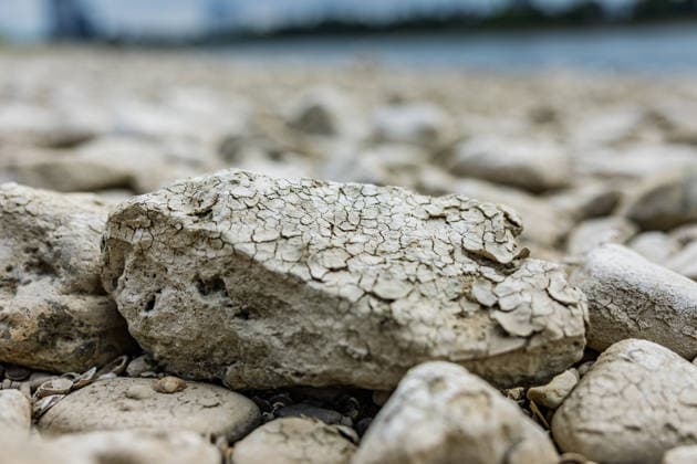
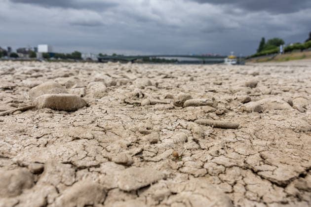
  • Niedrigwasser am Rhein vor dem UN Campus in Bonn Niedrigwasser am Rhein: Bei einem Pegelstand von 125 cm am Pegel Bonn liegt das Flussbett bis auf die tiefer liegende Fahrrinne trocken. Bonn Beuel Nordrhein-Westfalen Deutschland *** Low water levels on the Rhine in front of the UN Campus in Bonn Low water levels on the Rhine With the water level at the Bonn gauge station at 125 cm, the riverbed is dry except for the lower-lying navigation channel Bonn Beuel North Rhine-Westphalia Germany Copyright: xMarcxJohnx
  • Niedrigwasser am Rhein vor dem UN Campus in Bonn Niedrigwasser am Rhein: Bei einem Pegelstand von 125 cm am Pegel Bonn liegt das Flussbett bis auf die tiefer liegende Fahrrinne trocken. Im Hintergrund das Hochhaus-Ensemble aus Post Tower, Langer Eugen und Climate Tower auf dem UN Campus, wo das Sekretariat der UN-Klimarahmenkonvention UNFCCC über den globalen Klimaschutz verhandelt. Bonn Beuel Nordrhein-Westfalen Deutschland *** Low Water Levels on the Rhine in Front of the UN Campus in Bonn Low Water Levels on the Rhine With the water level at 125 cm at the Bonn gauge, the riverbed is dry except for the lower-lying navigation channel. In the background is the high-rise complex consisting of the Post Tower, Langer Eugen, and Climate Tower Copyright: xMarcxJohnx
  • Niedrigwasser am Rhein in Bonn-Beuel Niedrigwasser am Rhein: Bei einem Pegelstand von 125 cm am Pegel Bonn liegt das Flussbett am Beueler Rheinufer bis auf die tiefer liegende Fahrrinne trocken. Blick nach Norden auf die stark befahrene Kennedybrücke, im Hintergrund die gesperrte Nordbrücke (Friedrich-Ebert-Brücke). Bonn Beuel Nordrhein-Westfalen Deutschland *** Low Water Levels on the Rhine in Bonn-Beuel Low Water Levels on the Rhine With the water level at the Bonn gauge station at 125 cm, the riverbed on the Beuel side of the Rhine is dry except for the lower-lying navigation channel; view looking north toward the heavily trafficked Kennedy Bridge, with the closed Nordbrücke in the background. Friedrich Ebert Bridge, Bonn-Beuel, North Copyright: xMarcxJohnx
  • Niedrigwasser am Rhein in Bonn-Beuel Niedrigwasser am Rhein: Bei einem Pegelstand von 125 cm am Pegel Bonn liegt das Flussbett am Beueler Rheinufer bis auf die tiefer liegende Fahrrinne trocken. Blick nach Norden auf die stark befahrene Kennedybrücke, im Hintergrund die gesperrte Nordbrücke (Friedrich-Ebert-Brücke). Bonn Beuel Nordrhein-Westfalen Deutschland *** Low Water Levels on the Rhine in Bonn-Beuel Low Water Levels on the Rhine With the water level at the Bonn gauge station at 125 cm, the riverbed on the Beuel side of the Rhine is dry except for the lower-lying navigation channel; view looking north toward the heavily trafficked Kennedy Bridge, with the closed Nordbrücke in the background. Friedrich Ebert Bridge, Bonn-Beuel, North Copyright: xMarcxJohnx
  • Niedrigwasser am Rhein in Bonn-Beuel Niedrigwasser am Rhein: Bei einem Pegelstand von 125 cm am Pegel Bonn liegt das Flussbett am Beueler Rheinufer bis auf die tiefer liegende Fahrrinne trocken. Blick nach Norden auf die stark befahrene Kennedybrücke, im Hintergrund die gesperrte Nordbrücke (Friedrich-Ebert-Brücke). Bonn Beuel Nordrhein-Westfalen Deutschland *** Low Water Levels on the Rhine in Bonn-Beuel Low Water Levels on the Rhine With the water level at the Bonn gauge station at 125 cm, the riverbed on the Beuel side of the Rhine is dry except for the lower-lying navigation channel; view looking north toward the heavily trafficked Kennedy Bridge, with the closed Nordbrücke in the background. Friedrich Ebert Bridge, Bonn-Beuel, North Copyright: xMarcxJohnx